Officials outline early steps for expanding Gateway Arch National Park into East St. Louis riverfront
Planning begins around Malcolm W. Martin Memorial Park and nearby riverfront parcels
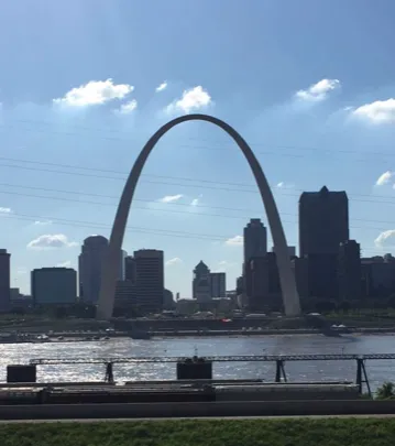
Regional and local officials are preparing to detail a proposal that would extend the footprint of Gateway Arch National Park across the Mississippi River into East St. Louis, a concept supporters describe as a long-term effort involving land evaluation, environmental work, and eventual boundary changes.
The initial focus centers on Malcolm W. Martin Memorial Park, an East St. Louis riverfront site directly facing the Gateway Arch, and adjacent areas that have been identified as potential additions. The park is owned by the Metro East Park and Recreation District, whose leadership has indicated a willingness to donate the property to the National Park Service if the project advances.
What land is under discussion
Concept materials discussed publicly to date have pointed to multiple tracts on the Illinois side of the river:
- Malcolm W. Martin Memorial Park, a riverfront park now owned by the Metro East Park and Recreation District (ownership transferred in 2005; the park opened in 2009).
- A forested area south of the park that has been cited as a possible site for park development.
- Additional riverfront acreage in the vicinity that East St. Louis has worked to assemble for future redevelopment, including parcels that have been tied to cleanup planning and grant-funded environmental work.
How the process works: studies first, then alignment and authorization
Organizers have framed the current phase as a “visioning” and feasibility effort rather than a finalized construction plan. Key early steps include evaluating land conditions, identifying environmental risks and potential remediation needs, and determining what investment would be required to make sites suitable for federal park purposes.
Because a national park’s boundaries are set through federal action, a central policy issue is whether the parcels under discussion match any existing congressionally approved expansion footprint and, if not, what technical boundary updates would be required. The process also requires coordination among federal, state, and local entities for land transfers and environmental compliance.
A decades-old idea with prior federal action
Expanding the memorial landscape into Illinois has been discussed in the St. Louis region for decades. National Park Service administrative history records show that federal law in 1984 authorized the Interior Department to designate up to 100 acres on the Illinois side of the Mississippi River as an enlargement of the memorial. Subsequent planning and environmental review work occurred in the 1980s and early 1990s, but the expansion did not move forward into on-the-ground implementation.
The current effort is being presented as a multi-step initiative expected to take years, with costs and a final concept dependent on study results and future funding decisions.
What comes next
In the near term, officials are expected to describe the scope of the planning work, including environmental testing and site assessments, and to outline how land donation and acquisition could be structured if the project proceeds. Organizers have also indicated that once a clearer concept is developed, the initiative would move toward cost estimates and a funding strategy that could combine private fundraising with public-sector support.
No construction timeline has been set. The next milestones are expected to be completion of early studies, a defined conceptual plan for public review, and any necessary federal boundary and authorization steps tied to a cross-river park footprint.